Pg. 1: Critical Overview | Pg. 2: Test Your Plug-in | Pg. 3: Interpreting Lightning Data | Pg. 4: Where to Find Lightning Data
Interpreting Lightning Data
Now that you've verified that your plug-in works, this page shows some very basic tips and features of OK-FIRST lightning data. Again, this is just the very basic stuff, and we urge you to come to the Fall 2005 re-certification courses to learn more about this tricky dataset. We also strongly, strongly encourage you to contact us if you have any questions about lightning data.
Interpretation Points:
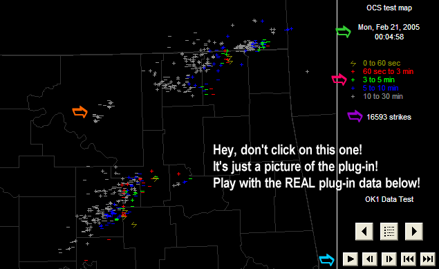
These refer to the color-coded markers on the above image. Feel free to play along with the plug-in data at the bottom of the page!
- Lightning data is updated every 60 seconds. The plugin will show the date and time of the latest lightning detection.
- Lightning data updates on a different schedule than radar data. This means that lightning data may "outrun" radar data, especially in fast-moving storms.
- The number of strikes lists the number of nationwide lightning detections in the last 30 minutes. We are currently unable to break it up into regional totals.
- The frequency of strikes has little to do with storm intensity. Increasing lightning strikes in a mature storm does not necesarily mean an increase an storm intensity! In fact, sometimes, it can mean the opposite. Likewise, a decrease in lightning intensity does not mean a decrease in storm intensity. There is no established, reliable relationship between lightning intensity and storm intensity. Use your experience, your spotters, and your other OK-FIRST data to assess storm intensity.
- Clicking on the lightning data item in the legend opens up a color-coded set of observations (go ahead, try it on the "OK1 Data Test" item below). The colors indicate which strikes are the most recent, and which are the most dated. You can toggle each of these categories on and off by clicking on the menu item. For example, if you don't want to see lightning that happened more than 10 minutes ago, click on the gray "10 to 30 min" in the legend. Presto! It's gone! Click again, and it's back!
- Polarity (positive strokes or negative strokes) has nothing to do with storm intensity or storm features. There is no proven relationship between positive strokes, negative strokes, tornadoes, hail, etc. Don't get hung up on sign: plus sign or minus sign, it's all dangerous.
- This example has animation/movie features, but we're not quite there on the OK-FIRST site. We plan to animate lightning data in the future.
- This is a limited deployment of lightning data. For now, lightning data is contained to two buttons in the "Radar" section of the OK-FIRST web pages. After the storm season, we will migrate lightning data to other parts of the site, based on its performance and your feedback.
- Again: OK-FIRST CAN ONLY DISPLAY LIGHTNING THAT HAS ALREADY HAPPENED. THERE IS NO WAY TO PREDICT THE FIRST STRIKE! Do NOT assume that zero lightning strikes means your jurisdiction is safe. Keep your eyes and ears attuned to developing situations!
- Have we mentioned that lightning data and lightning safety will be part of our fall recertification agenda, and we strongly encourage you to attend?
Now that you've seen some of the lightning basics, click here to see where we keep our OK-FIRST lightning data!
| Back to: OK-FIRST Home | Weather Briefing | "Classic" Current Data page | E-mail OK-FIRST |